Storm Pedro: France Under Water, Record Rainfall Since 1959
France has recorded 37 consecutive days of rain – a record since 1959 – and Storm Pedro has caused historic flooding, forcing Bordeaux to activate its emergency plan for the first time since 1999.
Unprecedented Meteorological Record Since 1959
France is experiencing a hydrological crisis of exceptional magnitude. Météo-France has confirmed that the country recorded 37 consecutive days of rain between January 14 and February 20, 2026, the longest uninterrupted streak since measurements began in 1959. Cities like Quimper received 580 millimeters of rainfall this winter, compared to an average of 412 millimeters, while Bordeaux reached 320 millimeters compared to the usual 260. February 2026 is already the wettest February ever recorded nationwide.
Garonne River Sees Century-Level Flooding in Marmande
The Lot-et-Garonne region has been the most devastated. The Garonne River reached 10.34 meters in Marmande, exceeding the previous record of 10.22 meters set in 2021 and marking the most significant flood since 1875, when the river peaked at 11.39 meters. According to France 3 Nouvelle-Aquitaine, approximately 1,700 people have been evacuated in the department, including nearly 1,000 in the town of Aiguillon alone. Faced with the scale of the situation, Prefect Bruno André requested reinforcements from the army, while 5,000 homes remained without electricity. In total, Enedis reported more than 33,400 customers without power in Nouvelle-Aquitaine and Occitanie.
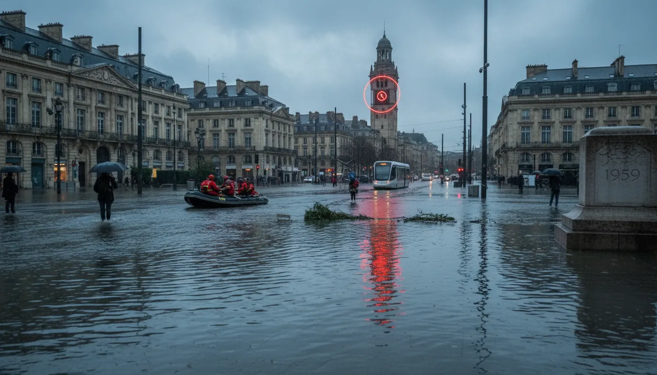
Bordeaux Activates Emergency Plan for First Time Since 1999
In Bordeaux, Mayor Pierre Hurmic triggered the Plan communal de sauvegarde on February 18, 2026 – the first time since the major storm of December 1999. The Bacalan, Chartrons, Bastide, Benauge, and Quai Sainte-Croix districts were among the most exposed. Reception centers were opened for evacuated residents, and nurseries and leisure centers were closed as a precaution. The flood peak was finally reached the next day at 7:20 a.m., with a level of 5.04 meters NGF, slightly lower than the most pessimistic estimates.
Up to 70 Departments Simultaneously on Alert
The hydrological crisis was not confined to the southwest. At its peak, 70 departments were simultaneously placed on flood alert. Five of them reached the maximum red alert level: Gironde, Lot-et-Garonne, Maine-et-Loire, Charente-Maritime, and Loire-Atlantique. In Saintes, some 900 houses were submerged in about fifty streets, while the Loire River overflowed near Angers. RTS reported that major overflows were expected in the Libourne and Bordeaux areas during the conjunction of high tides and Pedro's winds.
A Climate Alarm Bell
For climate specialists, this series of storms – Goretti, Ingrid, Nils, and Pedro – is not a simple meteorological accident. A warmer atmosphere retains more moisture, intensifying the violence of rainfall and reducing the periods of respite between episodes. The saturation of the soil, at its highest level ever measured in France in February, has eliminated any absorption capacity: every additional millimeter of rain ends up directly in the waterways. Authorities warn that the situation will remain critical until groundwater and soils return to a normal level – a prospect that could take several weeks.